Abstract
Abstract
Land management, urban planning, and legal compliance all depend on the prompt and accurate detection of encroachments and the establishment of land boundaries. Especially in vast or complicated land regions, traditional surveying methods are labor-intensive and prone to inaccuracy since they frequently rely on manual processes or GPS-based approaches. In this study, we offer a unique method to automate land boundary recognition and monitor encroachment in satellite and aerial photos using transformer-based deep learning models, specifically Vision Transformers (ViT). By utilizing transformers’ capacity to identify local and global patterns in high-resolution images, the suggested approach offers scalability and accuracy improvements over current techniques. Our approach compares predicted boundaries with historical geospatial data to detect encroachments by integrating boundary detection with a change detection pipeline. Extensive experiments on publicly available and custom geospatial datasets demonstrate that the transformer model outperforms traditional convolutional neural networks (CNNs) in terms of precision, recall, and Intersection over Union (IoU) scores. This paper also explores the integration of the proposed system with Geographic Information Systems (GIS) for real-time monitoring and visualization. The results indicate that transformer-based models can revolutionize land surveying by providing a robust, scalable, and efficient solution for boundary and encroachment detection.
Figures
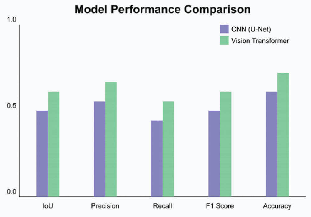
Figure 1:
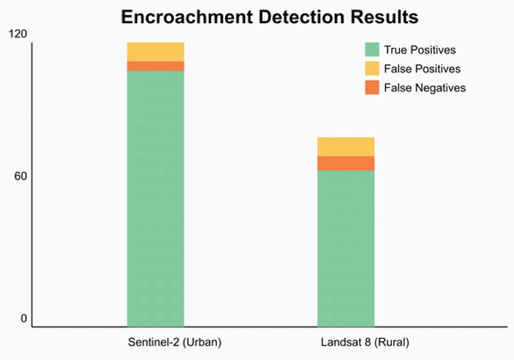
Figure 2:
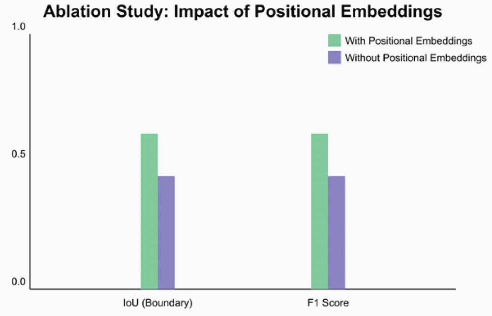
Figure 3:
References
-
Vaswani A, Shazeer N, Parmar N, e tal. (2017) Attention Is All You Need. In Advances in Neural Information Processing Systems (NeurIPS).
-
Dosovitskiy A, Beyer L, Kolesnikov A, et al. (2020) An Image Is Worth 16x16 Words: Transformers for Image Recognition at Scale. arXiv preprint arXiv: 2010.11929.
-
Ronneberger O, Fischer P, Brox T. (2015) U-Net: Convolutional Networks for Biomedical Image Segmentation. In International Conference on Medical Image Computing and Computer-Assisted Intervention (MICCAI).
-
Zhu X, Su W, Lu L, et al. (2020) Deformable DETR: Deformable Transformers for End-to-End Object Detection. arXiv preprint arXiv:2010.04159.
-
Belgiu M, Csillik O. (2018) Sentinel-2 Cropland Mapping Using Pixel-Based and Object-Based Time-Weighted Dynamic Time Warping Analysis. Remote Sensing, 10(2): 236.
-
Xia GS, Bai X, Ding J, et al. (2017) DOTA: A Large-Scale Dataset for Object Detection in Aerial Images. In IEEE Conference on Computer Vision and Pattern Recognition (CVPR).
-
Jean N, Burke M, Xie M, et al. (2016) Combining Satellite Imagery and Machine Learning to Predict Poverty. Science, 353(6301): 790-794.
-
Zou Q, Ni L, Zhang T, et al. (2015) Deep Learning Based Feature Selection for Remote Sensing Scene Classification. IEEE Geoscience and Remote Sensing Letters, 12(11): 2321-2325.
-
Qiu H, Jiang W, Huang Q, et al. (2021) A Survey of Machine Learning for Big Data Processing. EURASIP Journal on Advances in Signal Processing, 2021(1): 1-30.
-
Gevaert CM, Persello C, Vosselman G. (2016) Optimizing Multiple-Point Density Images for Tree-Crown Delineation Using High-Resolution Unmanned Aerial Vehicle Imagery. Remote Sensing, 8(9): 784.
-
Krause K, Nicholson W. (2020) Satellite Remote Sensing and Digital Image Processing. Wiley Online Library.
-
Wang X, Girshick R, Gupta A, et al. (2018) Non-local Neural Networks. In IEEE Conference on Computer Vision and Pattern Recognition (CVPR).
-
Good fellow I, Bengio Y, Courville A. (2016) Deep Learning. MIT Press.
-
https://planet.osm.org
-
United States Geological Survey (USGS). (2020) Landsat 8 Data User Handbook.